
Walk a Trussville Street
A Trussville street directory begins with one verified situs address. Situs means the physical address of the land, which can differ from the owner's mailing address. Once the county is known, the assessor or GIS record supplies the parcel ID, owner, legal description, subdivision, and deed clues. The map then makes it possible to move lot by lot along the same street. Ownership is public evidence. It is not a list of every occupant.
Keep a dated worksheet with one row per parcel. Record the situs exactly as displayed, including unit or directional text. Add the parcel ID, owner name, mailing city, subdivision, plat reference, municipality field, and maintenance date. This prevents two similar addresses or names from being merged. It also preserves a route back to the record when ownership changes.
- Verify the address and county in the parcel map.
- Open adjoining polygons and record each parcel ID, situs, and owner.
- Compare owner mailing addresses with the physical Trussville addresses.
- Carry each owner, legal description, or book and page into the correct Probate source.
- Add city permits or regional directories only for a specific address and date.
Split Trussville Streets by County
Trussville is mainly in Jefferson County, but incorporated land also reaches St. Clair County. Postal city and ZIP do not prove which county holds a parcel. This matters most on outer corridors and annexed land. A street list that crosses the boundary must be split before searching because Jefferson and St. Clair use different assessment, GIS, and deed access systems.
Jefferson County supplies CAPture, Parcel Lookup, and Landmark Web. St. Clair's public parcel layer exposes current and previous owner, sale and deed fields, but the official assessment link was broken during inspection and no public deed index was verified. For a St. Clair parcel, record the PPIN, current owner, previous owner, last-deed reference, sale date, subdivision, and year built. Then call Probate in Ashville at 205-594-2120 or Pell City at 205-338-9449.
A 2026 annexation example proves the trap. Three properties on Trussville Clay Road already carried 35173 Trussville mailing addresses before proposed annexation into the city. Mail identity came first. The parcel municipality, legal description, and filed annexation record settle the civic boundary.
Note: Treat ZIP 35173 as delivery geography until county and municipal fields agree with the parcel record.
Search Trussville Addresses in CAPture
Jefferson County CAPture is the direct starting point for most Trussville addresses. Its form presents radio choices for Name, Parcel#, or Address, followed by a text box and Search. Address is best for a street directory seed. Name helps when only an owner is known. Parcel number is the most exact route back to a chosen lot.
| Field label | Type | Required | Use on a street |
|---|---|---|---|
| Name | Radio choice plus text | Choose one mode | Find parcels tied to an owner |
| Parcel# | Radio choice plus text | Choose one mode | Return to one exact parcel |
| Address | Radio choice plus text | Choose one mode | Find the first situs on a block |
| Search | Button | Yes | Submit the selected query |
Do not stop at the first name. Move to the parcel details and compare the site address, owner mail, parcel ID, subdivision, legal description, plat book and page, acreage, municipality, school and fire districts, assessed values, and update date. Those fields explain the parcel's place in the address chain and lead to the deed system.
Map Both Sides of Trussville
Jefferson Parcel Lookup turns one Trussville address into a visual street walk. Search the exact address, confirm the situs, zoom until parcel polygons are clear, and click the lots beside and across from the target. The viewer provides Layers, Legend, Measurement, Details, Share, and Print tools. Separate county viewers add municipality, zoning, and flood context.
The underlying Jefferson parcel layer refreshes nightly and exposes owner, owner mail, situs, parcel, legal, plat, value, neighborhood, municipality, school district, and fire district fields. It has a 4,000-record service limit, but a normal block walk should stay far below that. A street name alone may have spelling or suffix variants, so start from a verified point and click outward.
The official Jefferson parcel data layer shows the source fields behind this method.
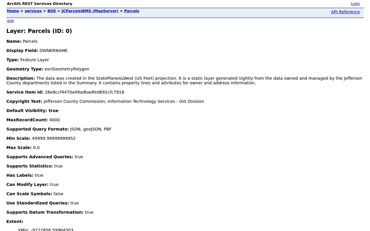
The layer's separate owner-mail and situs fields help keep a tax contact address from being mistaken for the property being mapped.
Trussville Owner Mail Versus Situs
Jefferson GIS stores owner mail in fields such as PROP_MAIL and stores the property site in ADDR_PSPR and its street components. This split is a useful Trussville quirk. If the mailing address differs, the owner may receive tax notices elsewhere. It does not prove vacancy, a renter, a second home, or any other household fact. The situs anchors the parcel; owner mail identifies where tax correspondence goes.
- Parcel
- A mapped unit of land with one tax identifier.
- Situs address
- The physical address assigned to the parcel.
- Plat
- A recorded map showing lots, blocks, boundaries, and easements.
- Criss-cross directory
- A historical directory arranged by street or telephone number.
A legal description is the durable bridge when a street name or number changes. Subdivision, block, lot, section, township, and plat references tie the place to deeds even if the postal label shifts. Preserve both the displayed address and legal data in the street directory worksheet.
Trussville Street Records Coverage
Each address-keyed source has a narrow role. The property roll maps owners. GIS shows the street geometry. Recorded instruments establish parties and transfers. City files document a specific permit, inspection, zoning, or occupancy event. Regional directories may identify a listed householder in a past year. VoterView cannot enumerate a street.
| Record set | Keeper | Street evidence | Access route |
|---|---|---|---|
| Assessment and parcel | Correct county revenue office | Owner, mail, situs, legal data | Portal or office |
| GIS parcel map | County GIS | Lots, adjacent parcels, districts | Free viewer |
| Deeds and plats | County Probate | Recorded parties and land description | Landmark or counter |
| Permits and zoning | City of Trussville | Applicant, work, plans, chronology | Address-specific request |
| Regional directories | BPL and Alabama Archives | Listed householder in a dated volume | Library or archive |
| Voter data | Alabama election officials | Lawfully released statutory fields | Order; limits apply |
Chain the systems through stable keys. The parcel ID returns to the assessment. A plat or legal description links the parcel to a deed. The deed gives grantor and grantee names. The exact situs gives city staff a defined permit request. For historical work, the street and house number lead into a dated reverse section, but the volume's Trussville coverage must be checked first.
Turn Trussville Parcels Into Deeds
For Jefferson County, carry each owner, book and page, instrument number, or legal description into Landmark Web. It offers name, document, book/page, consideration, record-date range, instrument number, legal, and quick searches. The free data view and watermarked first pages can identify a likely record. Full images cost $2 per page for registered small-volume users; subscribers pay $125 per month plus $1 per page.
Trussville ordinarily belongs to Jefferson's Birmingham Division. Its online index begins in 1987, and images begin in 1993. The often repeated 1965 online date belongs to the Bessemer Division and should not be applied to Trussville. For earlier land records, call the Birmingham Probate record room and use the direct and reverse indexes and deed books. The index is a courtesy tool, not the official record, and the office does not perform title searches.
A deed's grantee is the person receiving an interest; the grantor transfers it. Those roles identify a transaction, not every household member. Use the recorded legal description to ensure that a same-name party belongs to the parcel being traced.
Request Trussville Address Files
Trussville has no verified public permit, code-case, or municipal defendant-name index. The fallback is a narrow request by exact situs address. City Inspections at 5540 Trussville Clay Road handles construction, alteration, repair, fences, pools, accessory structures, HVAC, electrical, gas, plumbing, sprinklers, roofing, gutters, siding, driveways, and signs. The office can be reached at 205-655-5483 on weekdays from 7 a.m. to 4 p.m.
The city document request form has a $25 non-zoning retrieval charge, $10 certification, and $0.25 per-page copying. Labor after the first retrieval hour costs $15 per hour or part of an hour. Zoning packages range from a $50 digital standard letter to a $200 package with plans, variances, ordinances, resolutions, zoning cases, occupancy certificates, and road-project plans. Call Administrative Offices because the form does not state its submission channel or processing time.
Permit files may name an applicant, owner, contractor, subcontractors, the work, plans, and a sequence of inspections. These are event records. A permit applicant or contractor is not automatically a Trussville resident.
Note: Ask for an existing file and date range; a custodian need not create a new address list.
Read Older Trussville Streets
For a past street, consult the regional directory shelf rather than expecting a standalone Trussville series. Alabama Archives lists Birmingham Suburban directories from 1965 through 1994 and Jefferson County Metropolitan volumes from 1998 through 2004. Birmingham Public Library's broader directory holdings begin in 1883. The full collections and reading method are covered in the Trussville city directory.
A criss-cross section is arranged by street or phone number, which makes it useful for an address search. Check the title and coverage notes before treating every Trussville address as included. Pair the dated listing with a parcel, deed, census, obituary, school directory, or permit. Birmingham Public Library also holds street-name lists that can bridge an apparent address change. No authoritative citywide renumbering year was verified, so never invent one.
The historic Cahaba grid supplies recognizable address context. Poplar, Pine, Oak, Lake, and Magnolia run roughly east to west, while Brentwood, Rockridge, Chalkville, and Parkway run roughly north to south. The central mall uses North, South, East, and West Mall. A plat and parcel ID remain the safer bridge when a modern label differs.
Limits of Trussville Street Directory
A Trussville street directory can identify parcels, owners, recorded parties, permit applicants, and some dated directory listings. It cannot name every person who sleeps at an address. Renters, relatives, roommates, utility customers, and protected residents do not form one public household index. A homestead exemption may support owner-occupancy, but it is not a roster. Owner mail can differ from situs for many ordinary reasons.
VoterView is a personal verification tool that requires first name, last name, date of birth, and CAPTCHA. It cannot browse all voters on a street. State voter-list access is controlled by Ala. Code section 17-4-38, including changes effective June 1, 2026. Qualifying protected-victim data is withheld under section 17-4-33. Driver addresses are restricted under federal law, and no public Trussville utility-customer list was verified.
Record dates matter. GIS is a current snapshot, a deed records a transaction, and a regional directory reflects one edition. A responsible street search labels each fact with its source and date, distinguishes an owner from an occupant, and corrects errors with the original custodian.
Lawful use. Trussville address records are for lawful personal research. Never use street data to stalk, harass, threaten, or harm another person.