
Trussville Neighbor Lookup Sources
A block search is a layered task. Parcel geometry answers which lots touch. Assessment data adds owner-mail and situs fields. Deeds and plats describe transfers and the shared layout. Planning files may identify an applicant or speaker tied to one event. Voter information is governed by a separate Alabama statute. Filed covenants can establish an association or common duty, but no source alone proves everyone who lives behind each door.
| Source | What It Shows About a Block | Access |
|---|---|---|
| County GIS | Adjacent geometry, parcel IDs, owner fields, and layers | Free viewer or map service |
| Assessment | Owner mail, situs, value, and exemptions | Jefferson portal; St. Clair office fallback |
| Deeds and plats | Transfers, lot and block, common layout | Landmark or county Probate |
| Permits, zoning, minutes | Work, applicants, and named speakers | City request or published minutes |
| Voter file | Fields the statute permits for registered voters | Ordered file; protected data excluded |
| Filed covenants | Association name, duties, or contact if recorded | Probate or narrow city request |
Owner does not mean occupant. A mailing address that matches the situs can support owner occupancy, and a homestead status can be another clue, but neither creates a household roster. People who lease, share, or stay at a property may remain invisible. A Trussville neighbor lookup should label every result by what it actually proves.
Map Trussville Neighbors by Parcel
Begin with one exact address and verify its situs, which is the physical parcel address. In Jefferson County’s parcel viewer, zoom until parcel polygons are clear, click the lots that share a boundary, and open Details for each one. Layers or linked viewers can add municipality, zoning, and flood geography. Measurement tools can check distance and area, though no labeled front-end radius or buffer tool was verified.
- Search the exact address and confirm the point falls on the expected parcel rather than a nearby geocoder result.
- Record the parcel identifier, situs, owner, and owner-mail address for the starting lot.
- Click every adjoining polygon, then repeat the same fields without assuming each owner lives there.
- Check city limits, subdivision, voting, school, building, street, zoning, or flood layers only where the viewer provides them.
- Use deeds, plats, or filed covenants when parcel geometry raises a question the map cannot settle.
This method stays on the immediate block. A full named-road chain belongs in the Trussville streets lookup, where parcels are walked along both sides rather than just around one address.
St. Clair Trussville Block Layers
Trussville extends into St. Clair County, so a Jefferson-only search can omit nearby parcels. The St. Clair public parcel map service lists the layers available for that side of the city, including owner parcels, city limits, subdivisions, voting areas, schools, buildings, and streets.
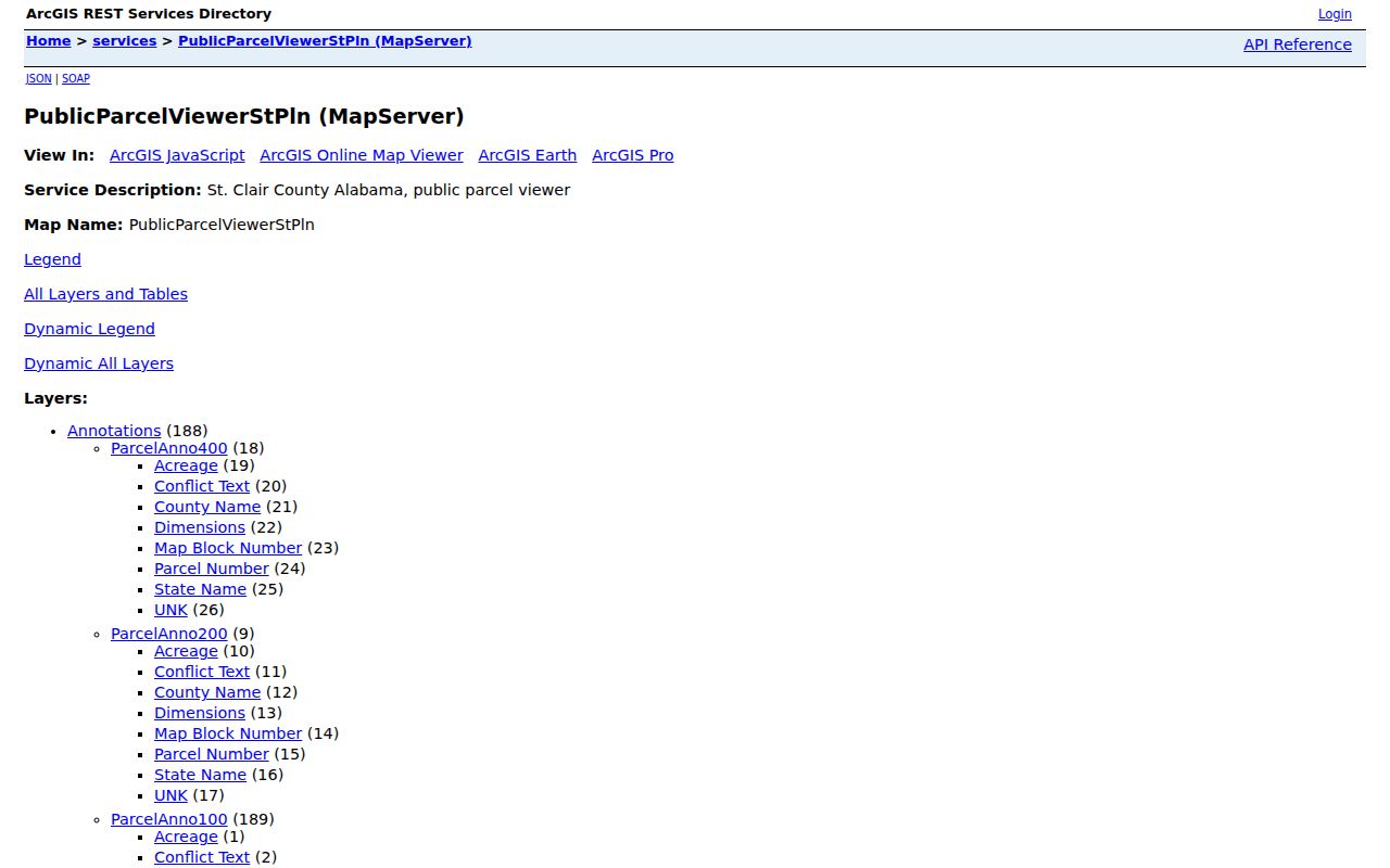
The layer inventory lets a block search test county and municipal context before any owner name is treated as a Trussville result.
The St. Clair parcel detail layer exposes current owner, previous owner, last deed, sale, subdivision, and improvement-year fields.
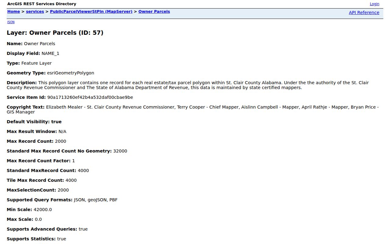
Those fields add useful context for adjacent lots, but the county Probate office remains the authority for the recorded deed and chain of title.
Enable Owner Parcels and City Limits first. Then add only layers needed for the question. Clicking the target and each adjoining lot is more reliable than treating a broad postal search as a block. The service has a 2,000-selection maximum, which is far beyond an immediate-neighbor task and does not justify bulk extraction.
Separate Trussville Owners and Occupants
Jefferson GIS refreshes nightly and deliberately separates owner-mail fields from situs fields. This is a useful local quirk. If the two addresses differ, the record still identifies the owner, but it gives no safe basis for naming the occupant. Even when they match, the file says nothing certain about relatives, roommates, or others at the site.
| Field | Meaning | Do Not Infer |
|---|---|---|
| Owner name | Assessment owner shown for the parcel | Every person at the address |
| Situs | Physical property address | Mail recipient or legal residence |
| Owner mail | Tax correspondence address | Location of the parcel |
| Homestead | Qualifying owner-occupancy evidence | Complete household membership |
| Previous owner | Prior assessment owner in St. Clair | Prior occupant or exact move date |
Deeds can confirm recorded parties and legal descriptions, while permits can name applicants, owners, or contractors tied to work. Those names serve different roles. Keep the role beside each name so a block worksheet never turns an applicant into a resident or an owner into a full household.
Trussville Associations Need Proof
No official citywide HOA inventory was found. The available evidence is fragmentary and event-specific. Carrington Lakes HOA appears in February 2022 Planning and Zoning minutes. Cahaba Project residents stated in 2018 that they had not formed an association. City zoning provisions require HOA maintenance documents for some townhome covenants, and neighborhood monument-sign rules contemplate HOA maintenance. None of those facts supports assuming membership from an address.
Carrington Lakes
Named in February 2022 planning minutes. Use the cited meeting record for that event, then request a filed covenant or contact sheet narrowly.
Cahaba Project
Historical community networks are documented, but residents reported no association in 2018. Do not invent a current roster.
Planning and Zoning
May hold covenants or maintenance documents required by an approval. Ask for an existing document tied to a named development.
The Trussville meeting-minutes archive can reveal applicants, speakers, projects, and associations connected to a dated matter. It is not a resident directory. A name in minutes proves participation in that event, not where the person now lives.
For an association question, ask for a named existing record: filed covenants, an approved maintenance agreement, a monument-sign responsibility sheet, or the exhibits attached to a specific planning case. Include the development name and meeting date when known. This keeps the request tied to public business and avoids asking staff to create an unverified list of neighbors or association members.
Trussville Neighbor Voter Boundaries
Alabama VoterView is not a neighbor browser. It requires first name, last name, date of birth, and a CAPTCHA for personal status and polling-place verification. The statewide voter file can contain statutory voter and district fields, but Ala. Code § 17-4-38 changed on June 1, 2026. Phone and email rules, dissemination, use restrictions, and electronic pricing changed while a legacy order form remained online.
A lawful county voter extract may support a block inquiry, but protected-victim information is excluded under Ala. Code § 17-4-33. Alabama has no party registration. Participation history may show which elections a voter took part in, never the choices marked on a ballot. Confirm current order terms with the Secretary of State before relying on the older form.
Note: Public VoterView verifies a known person; it cannot enumerate Trussville neighbors at nearby addresses.
Compare Trussville Neighbor Tools
Official rolls and commercial neighbor tools answer different questions. County records are narrower, but they disclose the keeper, field meaning, and correction path. Commercial compilations merge public and commercial data, which may be old, costly, or attached to the wrong person. Neither category should be mistaken for direct knowledge of a household.
| Source Type | Strength | Main Limit |
|---|---|---|
| County GIS and assessment | Current parcel geometry and defined owner fields | Owners, not all occupants |
| Probate deeds and plats | Official recorded parties and land descriptions | No household roster |
| City minutes and filed covenants | Event or development-specific names | Not proof of current residence |
| Commercial compilation | May gather broad leads | Stale, mismatched, or unclear sourcing |
For neighborhood curiosity, begin with the official parcel map and stop when it answers the land question. Add another source only when there is a lawful, specific reason to do so.
The Cahaba historic district shows why geometry and community are not the same thing. Its federal project included 273 residences and 264 contributing resources on garden-sized lots, creating a coherent physical pattern. Yet the historical Cahaba Association and later neighborhood life do not establish a present member directory. A mapped district can explain the shape of a Trussville block without identifying today’s occupants.
Trussville Neighbor Lookup Limits
Renters, relatives, utility customers, delivery data, driver addresses, and protected residents do not form an open Trussville block list. Public files also change. A nightly parcel layer is still a tax and mapping snapshot, while a filed deed records a transaction at a point in time. Association materials may be private unless a copy was filed with government or supplied under a lawful request.
A wrong parcel label should be raised with the county that maintains it. A wrong city-limit assumption should be checked against current GIS and filed annexation records. Avoid republishing sensitive addresses when a parcel number or general block description answers the civic question.
Maps also have timing limits. Jefferson’s layer refreshes nightly, but a recent deed or boundary action may still need review in the office that recorded it. St. Clair’s convenient previous-owner and last-deed fields are clues, not substitutes for the instrument. Date each result, preserve its parcel ID, and resolve conflicts with the custodian before drawing any conclusion about the block.
Lawful use. Use Trussville neighbor records for civic curiosity, reconnecting, or personal safety awareness. Never use them to watch, stalk, harass, intimidate, or harm anyone.